
Licence 61 (Tungolsky)
PetroNeft Resources wholly owned subsidiary «LLC Stimul-T» won the State Auction for the Tungolsky Licence No. 61 in the Tomsk Region of Western Siberia and acquired the Block in May 2005.In 2014 Oil India Limited acquired a 50% non-operated interest in Licence 61. PetroNeft remains the operator and owner of the other 50%.
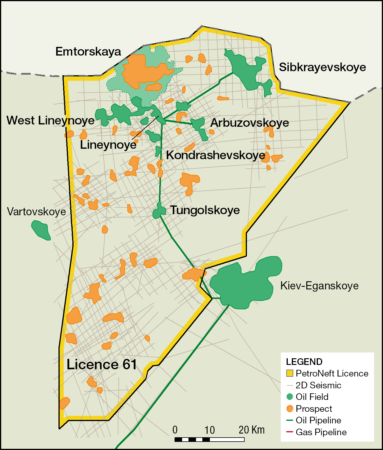
Licence 61
Highlights
· Tungolsky Licence 61 is located on the east side of the Ob River in the least explored oil bearing region of the Tomsk Oblast.
· The large 4,991 km² Licence contains 7 oil fields and over 25 identified prospects and leads.
· PetroNeft has thus far acquire 2,055 line kms of seismic data and drilled 12 exploration/delineation wells which exceeds the Licence work programme requirement and was completed ahead of schedule.
· Ryder Scott currently estimates the 2P reserves at 117.05 million bbls which includes 53.03 million bbls at Sibkrayevskoye (April 2013).
Development Timeline Highlights
· The 2010 the Lineynoye development work programme consisted of the construction of 9 development wells, central processing facilities and 60 kms of export pipeline. This extensive programme was executed on time and on budget.
· Lineynoye production commenced on schedule in Q3 2010 and after fracture stimulation peaked at 3,000 bopd at the end of Q1 2011.
· The 2011 work programme consisted of expanding the central process facility capacity to 14,800 bfpd design capacity, construction of 2 new pads, drilling of 14 development wells and three exploration/delineation wells.
· In August 2011 a sixth field was discovered at Sibkraevskaya. It contains over 50 million bbls of 2P reserves and is the largest single discovery made by PetroNeft to date.
· In mid 2012 the Arbuzovskoye oil field was brought into production following the construction of a 10 km pipeline and power line from Lineynoye to Arbuzovskoye and the drilling of new production wells at Arbuzovskoye.
· In March 2013 the initial development programme at Arbuzovskoye consisting of 6 wells was completed.
· Drilling recommenced at Arbuzovskoye in September 2014 following the Oil India farmout. An additional 5 wells on Pad 1 were completed in March 2013.
· The Tungolskoye oil field development commenced in 2015. This included the construction of a 26 km pipeline and power line to Lineynoye and drilling of 4 horizontal and 4 vertical wells.
· Development of the southern portion of the Arbuzovskoye field in planned in 2016.


Location
Licence No. 61 (Tungolsky) is located in the northern end of the Tomsk Region in Alexandrov administrative district. The climate is strongly continental, characterised by long cold (as low as −50°C) winters and short warm summers. Blizzards and heavy snowfalls persist from October till April. The average soil freezing depth is 1.2 m. The maximum frost penetration depth in swamps is 0.5 m. The snow cover reaches 1.5 m. The heating season lasts from
Seismic acquisition activities take place in the winter months. Drilling activities can take place year round provided the rig, supplies and heavy equipment have been moved to site during the winter months.
Brief History
Exploration on the Tungolsky Licence began in the 1960s with the acquisition of single trace analogue reflection seismic data. Common Depth Point (CDP) seismic data was acquired for the first time beginning in 1974. A total of 2,054 km of CDP data was acquired in the licence from 1974 to 1990. A total of 14 wells were drilled on Licence 61 during the Soviet era between 1970 and 1989. Two of these wells led to the discovery of the Lineynoye and Tungolskoye oil fields.
In 2005 PetroNeft engaged local consultants to reprocess and reinterpret all of the vintage seismic and well data on the Licence using modern technology. The combined reinterpretation of the 14 wells and seismic data allowed the Company to determine those structures with high potential for containing commercial quantities of oil.
The Company subsequently acquired 1,055 line km of high resolution CDP seismic data and drilled 10 exploration/delineation wells. As a result of these efforts the two Soviet era fields at Lineynoye and Tungolskoye have been successfully delineated and new oil fields have been discovered at West Lineynoye (2007), Kondrashevskoye (2008), Arbuzovskoye (2010), Sibkrayevskoye (2011) and North Varyakhskoye (2011).
Ryder Scott currently estimates the 2P reserves for the Licence area at 117.68 million barrels including the field discovery at Arbuzovskoye but Sibkrayevskoye will only be included in the year end 2011 Ryder Scott report. The current Russian registered GKZ C1+C2 reserves are 105 million barrels which does not include the new field discovery at Sibkrayevskoye.
Source rocks are present in the Lower Jurassic Togur and Upper Jurassic Bazhenov formations. The fields discovered to date on the Licence area have been in Upper Jurassic sandstone reservoirs. However, wells have successfully tested oil in Middle Jurassic and Lower Cretaceous sandstones in the adjacent Licences to the east and west. A 2008 study of vintage log data from old Soviet wells indicates potential missed pay in both Middle Jurassic and Cretaceous intervals in two wells in the southern part of the Licence area.
Licence and Work Programme
The Licence is a 25 year exploration and production licence that is valid until 2030 with 5-year exploration programmes to be agreed with the authorities during that period. The minimum work commitments under the Licence were to acquire 1,000 km of new 2D seismic data within three years and drill six wells within six years. Production of hydrocarbons should commence within two years of approval of commercial reserves. These commitments have all been met. Production can continue beyond the 2030 Licence deadline provided production is under an approved development plan.
In September 2015, we received a 5 year exploration licence extension for Licence 61. Within the period from 27 May 2015 to 26 May 2020, we must drill at least two prospecting/appraisal wells. The planned S-374 well in 2016 will qualify as one of these wells.


Lineynoye and West Lineynoye Development Status
In 2010 the Company started the development of the Lineynoye oil field with the construction of nine development wells, central processing facilities and 60 km export pipeline. Production commenced on schedule in late August 2010 and reached 3,000 bopd in Q1 2011 following fracture stimulation. Water injection for pressure maintenance commenced in June 2011.
The 2011 work programme consisted of expanding the Lineynoye central process facility to 14,800 bpd, construction of 2 new pads, drilling of 14 development/delineation wells. Ten of the Pad 2 wells were fracture stimulated in November 2011. The Pad 2 wells did not responded nearly as well as the Pad 1 wells to fracture stimulation and a number of studies were underway to better understand the differences and how to deal with them in the future (see Lineynoye and West Lineynoye Oil Fields).
In 2013 a temporary pipeline and power line were put in place connecting the West Lineynoye L-8 and L-7 wells to the Lineynoye central processing facility. In 2015 the L-10 pilot/horizontal well was drilled on the L-8 Lobe updip from the L-8 well. The results confirm our ability to use short segment horizontal drilling with a standard Russian exploration drilling rig to greatly increase production rates (see Lineynoye West Lineynoye Oil Fields). There are many follow-up locations to L-10 that can be developed in future years.
Arbuzovskoye Development Status
The Pilot Production Design for the Arbuzovskoye oil field was approved by the Russian State Central Development Committee in November 2011. A 10 km pipeline and utility line were constructed from the Lineynoye central processing facility to the Arbuzovskoye field in Q1 2012. Production through the pipeline commenced in May 2012. The initial development programme consisted of 6 wells and was completed in March 2013. The initial plans were to fracture stimulate the Arbuzovskoye wells similar to Lineynoye Pad 1, however the development drilling identified a water sand immediately below the oil reservoir so this was not feasible.
Following the Oil India farmout of 50% of Licence 61, drilling recommenced at Arbuzovskoye Pad 1. This programme was completed in March 2015. Four additional production and one water injection well were drilled. This drilling programme and additional 2D seismic acquired over the field in 2015 confirmed that the southern portion of Arbuzovskoye was oil productive and much larger in size than previously interpreted (see Arbuzovskoye Oil Field).
Development of the southern portion of the field is planned in 2016. The plan consists of up to 3 horizontal wells and one vertical/control well. Given the uniformity of the J1-1 reservoir and good flow rates in the Pad 1 wells vertical wells (A-102 over 500 bopd initial production), we expect very good results by utilizing horizontal wells in the development. The economics for this development are very good even in the current low oil price environment.Tungolskoye Development Status
Beginning in 2012, PetroNeft entered into an agreement with Tomsk Geophysical Company (TGK) to reprocess and reinterpret all of the existing seismic and well data at Tungolskoye and Traverskaya. This very comprehensive report that was finished in March 2013. The new structural map at Tungolskoye shows a large portion of the structure (>10 sq kms) up-dip from the existing T-1 and T-4 wells which encountered thick oil pays with good non stimulated test results.
Following the farmout to Oil India the T-5 pilot well was drilled near the crest of the structure and completed in October 2015. This well confirmed the structural interpretation and 8.2 metres of net pay. An open hole test was conducted over this interval and tested at a pro-rated inflow of 100 bopd unstimulated.
The horizontal segment of the Tungolskoye No. 5 well was then drilled and completed in the J1-1 and J1-2 Upper Jurassic intervals in early February 2016. The total horizontal segment was just over 350 metres of which over 80% was located in the productive J1-1 and J1-2 reservoirs. The well initially produced about 600 bopd using an Electric Submersible Pump (ESP) but subsequently began to cone water from a lower interval. The well confirmed the technical viability of utilizing horizontal wells in the development (see Tungolskoye Oil Field).
Development of the Tungolskoye oil field commenced in 2015. The development project included the construction of a 26 km pipeline and power line to connect the Tungolskoye oil field back to the Lineynoye central processing facility in Q1 2015. The programme initially included five horizontal (1,000 m horizontal segments) and up to six vertical wells. Drilling commenced in April 2015 and was completed in December 2015. The programme ultimately consisted of 4 horizontal and 4 vertical wells. The programme was revised after drilling the third well in the programme (T-508) which indicated a higher oil water contact than expected in the eastern part of the field.
The planned drilling programme at Tungolskoye is now complete.


